
The Meteorology Statal Agency, attached to the Ministry of Environment of the Ministry for Ecological Transition, activates its meteorological and climatological information system to support the correct performance of Operation Paso del Estrecho 2019 of the General Directorate of Civil Protection.
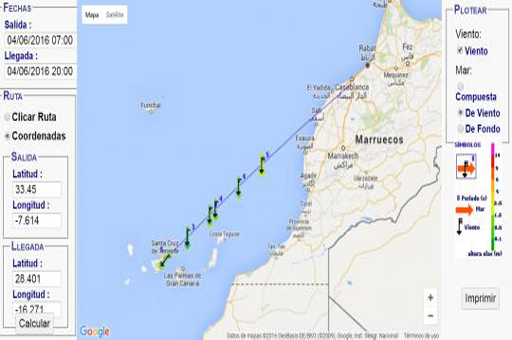
Specifically, the system offers up-to-date updated information on expected adverse weather phenomena, information on coastal and maritime numerical wave models, as well as meteorological and maritime forecasting in all areas of interest. This service is complemented by MeteoNav, the interactive and open access web tool developed by AEMET that offers maritime predictions on demand in any maritime crossing of the world whose duration does not exceed ten days.
Operation Paso del Estrecho takes place every year, from 1987, between June 15 and September 15, to facilitate the travel of a large number of Maghrebi workers living in Europe, who take advantage of their vacations to visit their countries of origin in the north of Africa. Specifically, last year 3,241,679 passengers and 734,240 vehicles moved.
This Operation is considered as a Special Civil Protection Plan launched by the Ministry of the Interior, through the General Directorate of Civil Protection and Emergencies, designed, structured and aimed at preventing risk situations and dealing with the contingencies that this entails. all mass movement of people.
AEMET provides meteorological and climatological support to the General Directorate of Civil Protection and Emergencies for the correct execution of OPE 2019. Among the functionalities provided by AEMET Operation Paso del Estrecho is it so:
• Updated information in real time of adverse weather events for the day itself and the next two in the main areas of interest following the guidelines of the National Plan of Prediction and Surveillance of Adverse Weather Phenomena (Plan Meteoalerta)
• Graphical outputs of the coastal and maritime wave numerical models. Specifically, the outputs of the SWAN coastal swell model are presented. The novelty this year is that this model will present information (significant height and average direction of the total sea) in much more specific domains allowing to offer very detailed data for the coasts of the Strait, Melilla, Malaga, Almeria and Murcia with a maximum range 48 hours Likewise, the outputs of the AEWAM sea swell model are shown with a maximum range of 72 hours.
Ministry for the Ecological Transition
• Prediction on the surface of the provinces involved in the execution of the Paso de Estrecho operation.
• And finally maritime prediction for the Straits and Mediterranean areas is attached.
This meteorological and climatological support service is complemented with MeteoNav, the Meteorological Service for maritime navigation. It is an interactive and free access web tool developed by AEMET that shows the prediction of several parameters of interest, such as winds or different types of waves, on any ocean route in the world of less than 10 days that the user indicates.
 Ministry for the Ecological Transition